Property Record
Arnold Rd, Memphis, TN 38118
This Property Is For Sale
NEARBY LISTINGS FOR SALE OR LEASE
Property Detail
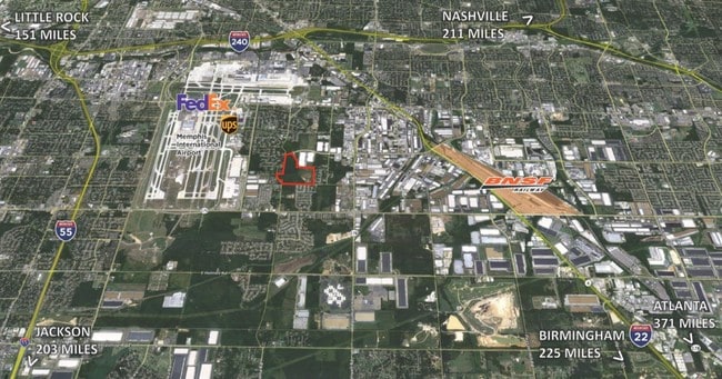
Arnold Rd
Memphis, TN-MS-AR
Countryside Busiiness Park Outline Plan
07-3088-0-0221
ES TCHULAHOMA RD SEE MAP 199N
Vacantlandnec
Shelby
X
Tennessee
47157C0440F
54.67 AC
2024
Airport
2025
Memphis
022600
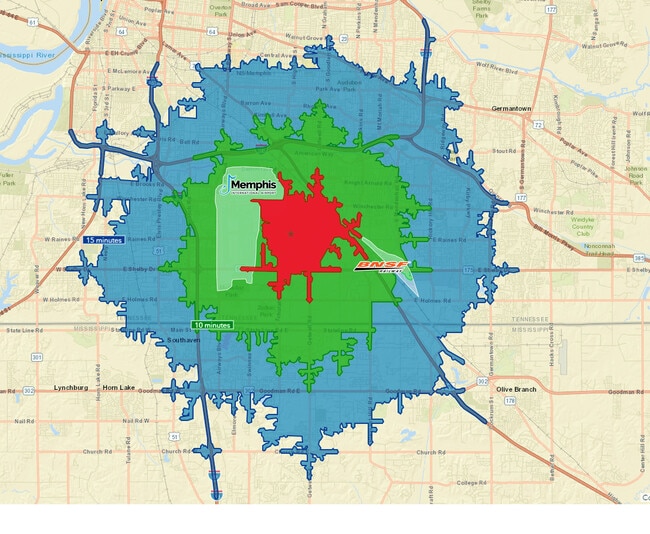
DEMOGRAPHICS near Arnold Rd
1 Mile
3 Mile
5 Mile
2024 Total Population
5,525
33,337
156,754
2029 Population
5,477
33,505
158,781
Pop Growth 2024-2029
(0.87%)
+ 0.50%
+ 1.29%
Average Age
36
35
36
2024 Total Households
2,025
12,144
58,128
HH Growth 2024-2029
(0.99%)
+ 0.54%
+ 1.31%
Median Household Inc
$43,824
$38,116
$41,125
Avg Household Size
2.70
2.70
2.60
2024 Avg HH Vehicles
2.00
1.00
2.00
Median Home Value
$76,994
$87,864
$113,254
Median Year Built
1972
1971
1969
Nearby Places
Map Layers
Map Styles
 Street
 Aerial
- Restaurants
- Banks
- Shops
- Fitness
- Groceries
PUBLIC TRANSPORTATION
AIRPORT
Memphis International
DRIVE
WALK
Distance
Memphis International
8 min
4.5 mi
Freight Ports
Port of Shreveport
DRIVE
WALK
Distance
Port of Shreveport
415 min
381.0 mi
Nearby Properties
Address
Land Use
TOTAL SIZE
Lot Size
Zoning
Address
Land Use
TOTAL SIZE
Lot Size
Zoning
1,013,319 SF
38.86 AC
EMP
Address
Land Use
TOTAL SIZE
Lot Size
Zoning
986,374 SF
68.79 AC
CA
Address
Land Use
TOTAL SIZE
Lot Size
Zoning
969,150 SF
64.49 AC
EMP
Address
Land Use
TOTAL SIZE
Lot Size
Zoning
717,155 SF
83.34 AC
CA
Address
Land Use
TOTAL SIZE
Lot Size
Zoning
897,076 SF
47.33 AC
CA
Address
Land Use
TOTAL SIZE
Lot Size
Zoning
865,065 SF
51.05 AC
CA
Address
Land Use
TOTAL SIZE
Lot Size
Zoning
838,318 SF
39.56 AC
I-L
Address
Land Use
TOTAL SIZE
Lot Size
Zoning
586,847 SF
37 AC
CA
Address
Land Use
TOTAL SIZE
Lot Size
Zoning
237,911 SF
21.38 AC
EMP
Address
Land Use
TOTAL SIZE
Lot Size
Zoning
118,116 SF
60.70 AC
CMU-2
Address
Land Use
TOTAL SIZE
Lot Size
Zoning
571,642 SF
23.56 AC
EMP
Address
Land Use
TOTAL SIZE
Lot Size
Zoning
180,831 SF
13.11 AC
EMP
Address
Land Use
TOTAL SIZE
Lot Size
Zoning
1,034,433 SF
53.32 AC
EMP
Address
Land Use
TOTAL SIZE
Lot Size
Zoning
861,322 SF
72.92 AC
CA
Address
Land Use
TOTAL SIZE
Lot Size
Zoning
279,419 SF
172.07 AC
EMP
Address
Land Use
TOTAL SIZE
Lot Size
Zoning
357,582 SF
5.61 AC
EMP
Address
Land Use
TOTAL SIZE
Lot Size
Zoning
328,300 SF
33.78 AC
CA
Address
Land Use
TOTAL SIZE
Lot Size
Zoning
853,440 SF
39.22 AC
EMP
Address
Land Use
TOTAL SIZE
Lot Size
Zoning
321.59 AC
R-8
Address
Land Use
TOTAL SIZE
Lot Size
Zoning
739,205 SF
31.51 AC
AG
Address
Land Use
TOTAL SIZE
Lot Size
Zoning
265,600 SF
22.03 AC
CA
Address
Land Use
TOTAL SIZE
Lot Size
Zoning
654,400 SF
46.39 AC
EMP
Address
Land Use
TOTAL SIZE
Lot Size
Zoning
714,692 SF
30.88 AC
EMP
Address
Land Use
TOTAL SIZE
Lot Size
Zoning
2,847.82 AC
EMP
Address
Land Use
TOTAL SIZE
Lot Size
Zoning
188,458 SF
29.19 AC
RU-3
Address
Land Use
TOTAL SIZE
Lot Size
Zoning
605,539 SF
28.59 AC
RU-1
Address
Land Use
TOTAL SIZE
Lot Size
Zoning
47.65 AC
R-8
Address
Land Use
TOTAL SIZE
Lot Size
Zoning
618,133 SF
37.58 AC
EMP
Address
Land Use
TOTAL SIZE
Lot Size
Zoning
508,104 SF
36.83 AC
EMP
Address
Land Use
TOTAL SIZE
Lot Size
Zoning
585,535 SF
31.96 AC
EMP
The World's #1 Commercial Real Estate Marketplace
Connect with us
© 2025 CoStar Group
The information above has been obtained from sources believed reliable. While we do not doubt its accuracy we have not verified it and make no guarantee, warranty or representation about it. It is your responsibility to independently confirm its accuracy and completeness. Any projections, opinions, assumptions, or estimates used are for example only and do not represent the current or future performance of the property. The value of this transaction to you depends on tax and other factors which should be evaluated by your tax, financial, and legal advisors. You and your advisors should conduct a careful, independent investigation of the property to determine to your satisfaction the suitability of the property for your needs.